
Feature your business, services, products, events & news. Submit Website.
Breaking Top Featured Content:
Industrial Northwest Redevelopment Plan Includes Streetcar Extension and Housing
by Taylor Griggs
Northwest Portland has seen significant changes over the last several decades. The Pearl District and Slabtown neighborhoods, formerly dominated by industry, are now some of the city’s chicest enclaves—with an impressive number of affordable housing developments and public transit options to boot.
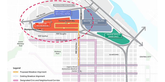
But Northwest Portland’s transformative projects have mostly remained south of NW Vaughn Street, leaving a lot of formerly-industrial land underutilized. Enter the Montgomery Park Area Plan (MPAP), a joint venture out of the Portland Bureau of Transportation (PBOT) and Bureau of Planning and Sustainability (BPS). The plan proposes land use and transportation changes to effectively create an entirely new neighborhood west of Highway 30 between NW Vaughn and NW Nicolai streets.
The plan area. city of portland
For public transit enthusiasts, the MPAP’s biggest draw is its proposal to add 1.3 miles of new Portland Streetcar track alongside NW 23rd Avenue to Montgomery Park. But what good is a new streetcar line if there’s no destination to travel to? That’s where the land use changes come in. Ultimately, planners envision a neighborhood with thousands of new housing units, more job opportunities, increased green space, and other amenities.
That’s a stark contrast to what the area looks like today. Right now, the Montgomery Park plan area is defined by its eponymous building, the historic warehouse and the former home of the Montgomery Ward department store. The building is now best known for its iconic roof sign and housing the Adidas Employee Store. ESCO steel’s main production plant used to live just east of the Montgomery Park building, but since it closed in 2015, its former site is now mostly just a vacant lot.

(Mostly) empty parking lots in the NW Industrial Area. taylor griggs
The entire plan area has an abundance of pavement dedicated to car parking, most of which is hardly used. Compared to the hustle and bustle on NW 23rd just a few blocks south, the site surrounding the Montgomery Park building feels desolate, even in the middle of the day.
But all that is set to change.
What’s in the plan?

A potential new layout for NW Roosevelt. portland streetcar
While the Montgomery Park Area Plan proposed draft was just released in April, the plan has been in the works for a long time. Leaders from PBOT, Portland Streetcar, TriMet, and Metro have been considering parts of this plan since 2009, and the planning process really ramped up over the last six years.
Through that process, MPAP planners came up with the land use concept for the site, proposing the area be zoned for both industrial and transit-oriented, mixed-use development, on the east and west sides of Highway 30 respectively, buffered by NW Nicolai Street.
The MPAP draft proposal states the concept “strives to preserve active industrial land by limiting land use changes east of Highway 30.” The land use concept is also designed to “minimize conflicts between the new mixed-use area and existing heavy industrial areas” north of NW Nicolai Street using an “employment zoning buffer area” with a broad range of employment uses (beyond industrial) but no housing.
“Overall, the concept balances the need to retain industrial lands and jobs with the opportunity to create a vital new transit-oriented, mixed-use neighborhood with significant public benefits such as additional affordable housing and affordable commercial space,” the plan states.
The streetcar extension would run along NW 23rd Avenue and circulate through the plan area on a one-way parallel couplet along NW Roosevelt and NW Wilson streets. The plan also proposes extending NW Roosevelt, NW Wilson, and NW York Streets, as well as NW 25th Avenue, into the project area and eliminating the current “superblocks” which block connectivity in the area. Some of these streets will see other infrastructure changes—for example, the plan proposes building protected bikeways on NW Roosevelt and NW Wilson from NW 23rd to 26th Avenues, alongside the new streetcar track.
On NW Vaughn Street—which will serve as the transition street into the new Montgomery Park neighborhood from the south—the city wants to encourage more tree planting and will attempt to minimize freight travel through the area. Already, PBOT has placed new crossing infrastructure along NW Vaughn to make it safer to cross the street by foot or bike.
Vision for a burgeoning neighborhood
A key part of the MPAP’s implementation plan involves a public benefits agreement between the city and the two largest property owners in the plan area. The agreement would seek to “direct some of the value created from the change in land use regulations and transportation investments toward providing broader public benefits.” Such benefits include affordable housing, employment opportunities, and a new open space or park.
Since there is very little existing housing in the plan area, the project is not expected to displace residents or contribute to increased housing costs in the immediate vicinity. But the plan proposes investing in affordable housing in the area, which may help those employed nearby in the new mixed-use district or in the nearby industrial zone.
The plan proposes several mechanisms for increasing employment and business opportunities, as the proposed zoning changes away from industrial and employment use may impact existing jobs.

A new vision for Montgomery Park. city of portland
According to the draft proposal, the plan will require “minimum amounts of non-residential floor area in new development to accommodate employment” and create incentives to promote “specific types of employment use.” The plan also seeks to facilitate affordable commercial space rentals and ownership to increase business opportunities for smaller, local enterprises.
Property owners would also be required to create a publicly accessible open space or park in order to fill a need for green space to serve the people who live and work in the new district. The park would be co-owned and maintained by Portland Parks & Recreation, but funded upfront by private entities.
Finally, the public benefits agreement in the plan requires property owners to assist in creating a commemoration of York, an enslaved member of the Lewis and Clark expedition, in a publicly accessible and significant location within the MPAP area. York, who NW York Street is named after, is significant to the area because the 100-year anniversary of the Lewis and Clark exhibition was celebrated at this site in 1905.
Planners hope these elements will support their vision for the Montgomery Park area of the future: A “vibrant, equitable mixed-use neighborhood,” that is “part of a dense and diverse Northwest Town Center.”
“The neighborhood streets and public spaces are safe, and lively with pedestrians and cyclists,” the plan states. “The former ESCO steel site, and several other individual properties in the area have developed with vital new mixed-use buildings that include spaces for employment, affordable housing and active ground floor uses. While the new neighborhood has a residential component, the area continues to have a significant employment focus and supports well-paying middle-wage jobs.”
Portland Streetcar extension could bolster transit options

The Portland Streetcar currently loops around at NW 23rd Avenue and Northrup Street.
taylor griggs
The Montgomery Park project area is one of the places in Portland where century-old streetcar tracks are still visible through the pavement, offering glimpses of the city’s rich transit history. Now, planners want to bring the streetcar back to the neighborhood—the best tool, they say, for Montgomery Park’s revitalization.
The planned extension would also bring some renewed energy to the Portland Streetcar, considering the city hasn’t completed a new streetcar project since 2015.
Much of Northwest Portland is already accessible by streetcar, so planners decided it would make sense to create a seamless connection to the new Montgomery Park development. Portland Streetcar boosters also say the mode of transportation has been uniquely successful in driving economic and social success along its corridors.

Old streetcar tracks leading up to the Montgomery Park building.
taylor griggs
Andrew Plambeck, public affairs manager at the Portland Streetcar, and PBOT Commissioner Mingus Mapps both used the word “catalyst” to describe the streetcar in a recent video about the extension plan.
“Streetcar is a catalyst for walkable urban development that connects new housing to job centers and major institutions,” Plambeck said. “Portland’s history shows that streetcars are always a good investment.”
The streetcar boasts an impressive connection to local affordable housing projects, with 40 percent of the city’s affordable housing construction since 2001—the year the revitalized streetcar debuted—taking place along streetcar routes. Its ridership has also been shown to be more diverse and transit-dependent than the city as a whole.
One thing that’s different about the proposed new streetcar track to the Montgomery Park area: There are no overhead wires. The new streetcar extension is proposed to be entirely off-wire, using battery technology only. Streetcars can use both the wire and wireless tracks, and planners say going off-wire will reduce construction and maintenance costs. (Some local transit aficionados aren’t so sure.)
Wires or not, the streetcar extension proposal is a central component of the Montgomery Park development plan.
“Streetcar was chosen because of its suitability to support the densest development for the area,” the MPAP transportation draft states. “Streetcar offers the highest capacity of any of the alternatives and draws high ridership, with a proven background of spurring dense development including affordable housing.”

The Portland Streetcar extension map. city of portland
According to PBOT, the bureau expects to present a proposal for the streetcar extension this summer or fall, and may seek federal funding for the project. If it’s funded, construction could be underway as soon as 2026, encouraging housing and commercial development in the project area.
Residents can offer public comment on the MPAP draft plan on the Portland Map App. The deadline for public testimony is May 21, when the Portland Planning and Design commissioners will hold a joint public hearing.
Continue Reading at PortlandMercury.com here