
Feature your business, services, products, events & news. Submit Website.
Breaking Top Featured Content:
Hurricane Chaos: FAA Warns “May Pause” Flights Across Florida; Tampa Port Signals Condition “ZULU”
Update (1538ET):
Parts of Key West are already observing high wind gusts and rain from Hurricane Idalia. The Federal Aviation Administration has begun rerouting planes from Florida and closing Gulf routes this afternoon.
The FAA warned on X, formerly known as Twitter, that flights in and out of Palm Beach International Airport, Miami International Airport, and Fort Lauderdale-Hollywood International Airport could be disrupted in the next 12 hours.
The FAA is re-routing aircraft and closing Gulf routes as Hurricane #Idalia is expected to hit the Florida region Wednesday morning. We may pause flights in and out of @flyPBI, @iflymia and @FLLFlyer to keep you safe. Monitor https://t.co/smgdqJNBiL. #FAAWeatherSquad pic.twitter.com/xkwSDMsuGy
— The FAA ✈️ (@FAANews) August 29, 2023
Meanwhile, Port Tampa Bay, the largest Florida port by tonnage and land, closed all waterways, setting port condition ZULU. This means the port is preparing for the “possibility of gale force winds (34-47 knots) entering the Bay in the next 12 hours.”
THREAD 4/4: Additionally, port staff will continue to work round-the-clock so we can re-open to full operations as soon as safely possible to support the community and region we serve.
All weather-related updates will be posted here: https://t.co/Z2KqPHm3pN
— Port Tampa Bay (@PortTampaBay) August 29, 2023
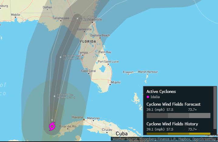
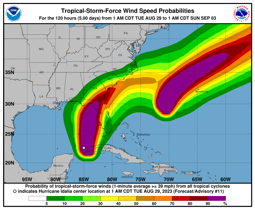
As of this afternoon, Idalia had maximum sustained winds of 90 mph, churning approximately 240 miles to the southwest of Tampa, as it maintained a northward trajectory at a pace of 15 mph.
Radar with grid lines is helpful
Hurricane Idalia is along 85°W and we’re watching for wobbles and any hints of eastward movement. pic.twitter.com/2zd0tOVnBR
— Ryan Maue (@RyanMaue) August 29, 2023
… and this
ON THIS DATE IN 2005: Hurricane Katrina made landfall as a category three storm over Southeast Louisiana and Mississippi. The majority of the loss of lives in Hurricane Katrina was due to flooding caused by fatal engineering flaws in the flood protection system, specifically the… pic.twitter.com/Yy8tDYnRQr
— James Spann (@spann) August 29, 2023
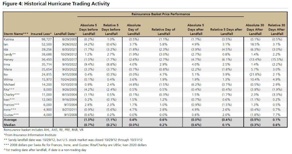
This is how the stock market reacts following major hurricanes striking the US:
The S&P 500’s median change the day after prior ‘major’ hurricanes since 1990 made landfall was a gain of 0.32% with gains 72% of the time. pic.twitter.com/FkfLo4rD6P
— Bespoke (@bespokeinvest) August 29, 2023
UBS sheds more color on trading activity after major hurricane strikes:
With Hurricane Idalia looking like it’s going to make landfall by about 8:00 New York on Wednesday, below is analyst Brian Meredith gave his view on the potential impact. The range of outcomes here is large – preliminary estimates on Aug. 28 from Risk Management Solutions implied average insured losses of $9.36 bn with a 50% probably of losses exceeding $4.05 bn and 10% probability of losses of $25.6 bn.
* * *
According to the latest update by the National Hurricane Center, Hurricane Idalia formed early Tuesday morning and is currently 320 miles south-southwest of Tampa. With maximum sustained winds of 80 mph, Idalia is a Category 1 hurricane.
NHC expects Idalia to ‘rapidly intensify’ later today and could strike the Gulf Coast of Florida as a Category 3 or above on the Saffir-Simpson hurricane wind scale on Wednesday morning.
“Rapid intensification is likely through landfall, and Idalia is forecast to become an extremely dangerous major hurricane before landfall on Wednesday,” said NHC senior hurricane expert Eric Blake.
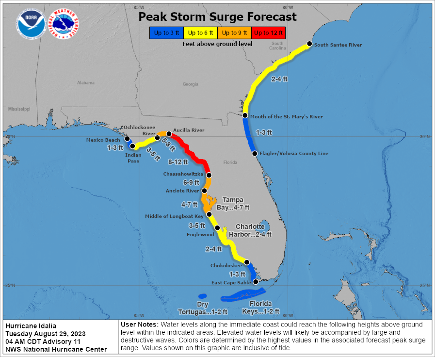
🗣️ WRAP UP PREPARATIONS! #HurricaneIdalia continues to move north!
Potential Impacts:
🌊8-12′ storm surge further north, 4-7′ Tampa Bay
🌬️ TS/H force winds depending on location
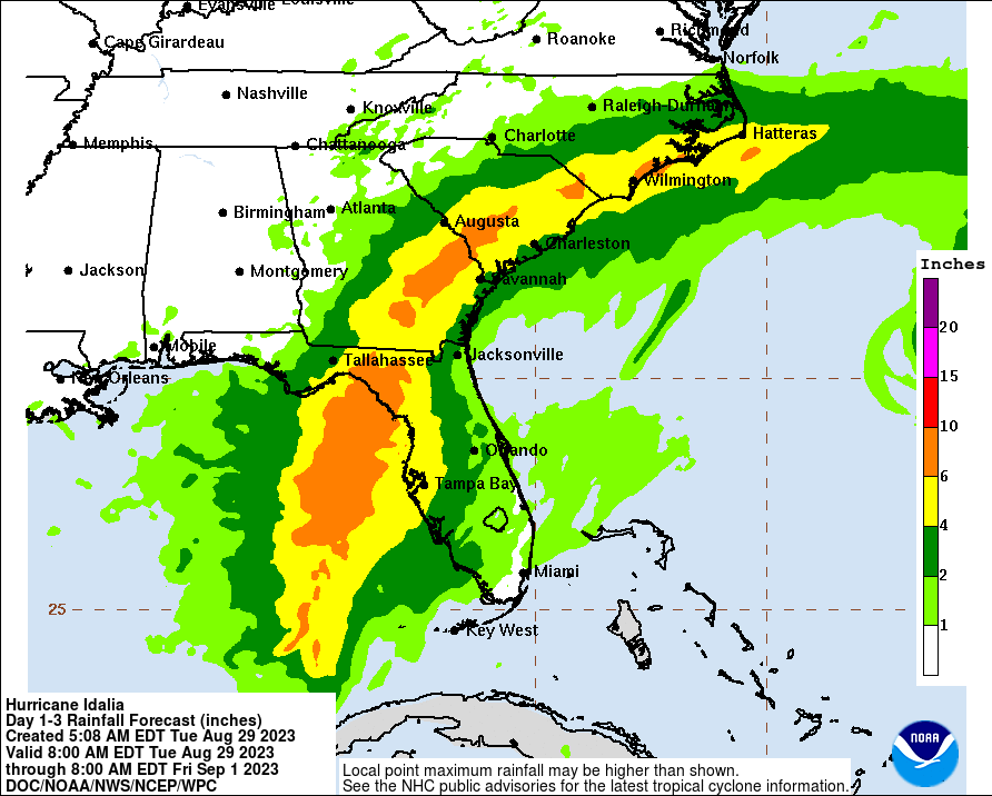
🌧️4-8″ rain with locally higher amounts
🌪️ Several tornadoes possible¡Vea gráfica en Español!#FLwx pic.twitter.com/kIZFxtqUBY
— NWS Tampa Bay (@NWSTampaBay) August 29, 2023
Landfall is expected between 0800 and 1000 ET tomorrow around the north of Tampa, but any shift in trajectory could put the metro area of 400,000 in jeopardy.
NHC predicts Florida’s Big Bend area could be flooded with 12 feet of storm surge.
Rainfall between 6 to 12 inches is expected.
Forecasters predict sustained winds of 120 mph with gusts up to 150 mph before the storm makes landfall.
“This is going to be a major hurricane,” said Gov. Ron DeSantis from the state Emergency Operations Center in Tallahassee Monday.
DeSantis continued, “It’s likely to continue strengthening all the way until impact and it could have catastrophic storm surge in your area.”
“If this storm hits at high tide, storm surge could and would reach 8 to 12 feet in some areas and so that would be life-threatening storm surge,” the governor said.
He said the Big Bend area of the state hasn’t been blasted with a hurricane of this strength in decades.

Ron DeSantis has ordered the activation of the National Guard while the Federal Emergency Management Agency announced President Biden approved an emergency declaration for the Sunshine State.
Tyler Durden
Tue, 08/29/2023 – 15:38
Continue reading at ZeroHedge.com, Click Here.