
Weather Tools
Search Featured Websites:
Feature your business, services, products, events & news. Submit Website.
Breaking Top Featured Content:
Feature your business, services, products, events & news. Submit Website.
Breaking Top Featured Content:
Severe thunderstorms expected in Iowa tonight with snow possible Thursday
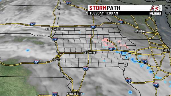
A Slight Risk or level 2 of 5 has been issued for much of central Iowa. The best chance for severe storms will be in the evening and early overnight hours (7 PM-midnight). Storms will develop in southwest Iowa and move northeast late this evening. Large hail remains the biggest threat, but we could also see damaging wind gusts up to 60 mph. While the tornado threat remains low, the best chance for any tornadoes would be around sunset (7-8 PM) in southwest Iowa.
This afternoon
Overall most of today will be quiet and cloudy, but windy. Light drizzle will work its way from southwest Iowa to northeast Iowa during the late morning and early afternoon. Winds will be strong from the southeast at 20-30 mph.
Temperatures will vary depending on where you are. Northern Iowa will stay about 20° colder than southern Iowa. Expect highs in the upper 30s and low 40s from the Iowa/Minnesota border to the Hwy 20 corridor. If you draw a diagonal line starting at Sioux City (NW Iowa) and ending in Mount Pleasant (SE Iowa) this is where temperatures will be in the upper 40s to low 50s. Southwest Iowa will be the warmest part of the state. This is where the warm front will make it before sunset, which will result in highs in the upper 50s and low 60s.

This evening
Storms are expected to develop first in southwest Iowa between 6 and 8 PM. This is when we could see a few isolated tornadoes, although the chance for tornadoes still remains low. The main threat is for large hail and some gusty winds as storms continue to develop and move into central Iowa.
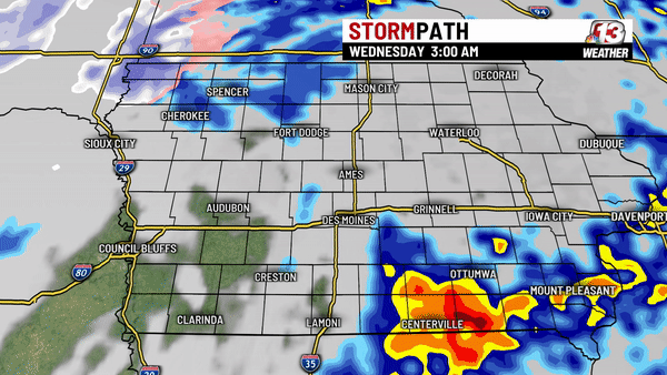
Most of the storms will move through central Iowa between 9 PM and midnight with a few storms still in eastern and southeastern Iowa after midnight. Most will see less than a quarter-inch of rain, while a few areas that do see thunderstorms may see up to an inch.

Wednesday
Cloud cover will remain through early Wednesday morning, but most of the showers will move out of the state with the cold front before noon.
Despite a mild start to Wednesday, the air following the cold front will cool temperatures throughout the day. Expect temps in the lower 50s early Wednesday with the lower 40s in the afternoon. In addition to the cooling temperatures, the wind will be out of the NNW at 10-25 mph, which will actually make it feel like the lower 30s through most of the day. Some light showers are possible, though accumulation will be less than a tenth of an inch
Wednesday night into Thursday
Colder air will continue to arrive late Wednesday with temperatures falling into the lower 30s, however, similar to Wednesday afternoon, Wednesday night will be just as windy, so temperatures will feel more like the lower 20s. There will still be a bit of moisture following late Wednesday through early Thursday, but temperatures will be cold enough for snow to fall. Accumulation will be less than a half inch. The strong NW wind will also make any accumulation tough to measure.

Thursday afternoon will be dry but mostly cloudy with temperatures in the lower 40s. The wind will also gradually let up throughout the day.
Friday will be rather pleasant as sunshine and 50s return, but more rain is possible late Friday into Saturday morning.
For the latest forecast, visit www.WHO13.com/weather.
Continue Reading at WHO13.com here