
Feature your business, services, products, events & news. Submit Website.
Breaking Top Featured Content:
Weekend whiplash: thunderstorms to snow for Iowa

The ingredients are setting up to make for a severe weather day for Central Iowa on Saturday. Most of the state of Iowa is included in its first slight risk area for severe weather of 2022. We will then deal with another weather whiplash as we will transition from severe storms on Saturday to snow by late Sunday night.

Central Iowa is most likely to see a few storms that will produce hail and damaging winds Saturday afternoon through Saturday evening. An isolated tornado or two may spin up as well.

A low pressure center forming over northern Kansas will lift northeast toward Iowa and crossing the state Saturday evening. A shortwave trough will be accompanying this low. A strong low level jet will pull in plenty of moisture from the lower Mississippi Valley and Ozarks into Iowa. A few thunderstorms may pop up early in the day with this warm air advection and moisture in the morning. There may be an isolated threat of hail with this early possibility of storms.
Thunderstorms later in the day will form along the Iowa-Nebraska border along the incoming cold front. These storms have more potential to produce hail and damaging winds, as well as the tornado threat. These storms will move quickly across Central Iowa to the northeast. Despite 50 degree dewpoints, temperatures rapidly cooling temperatures aloft will allow for storms to quickly build. There were also be plenty of wind shear allowing for the development of some rotation within some storm cells.
The strength of the storms will weaken as they cross east past I-35 later Saturday evening.
Once the storms move through, cold air and strong northwest winds will rush into the state. This will lead to quickly falling temperatures back to the 30s by early Sunday morning. There will be a little light snow wrapping around the low in northwest and northern Iowa through midnight Saturday night.
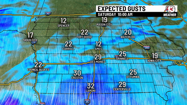
Winds will stay strong gusting up to 40 mph through early morning Sunday.
Another storm system brings more moisture up from the southwest late Sunday night through early Monday morning. This may bring a brief hit of snow that could accumulate in southeast Iowa through early Monday morning.

Continue Reading at WHO13.com here