
Feature your business, services, products, events & news. Submit Website.
Breaking Top Featured Content:
High heat, humidity bring a chance for severe weather tonight
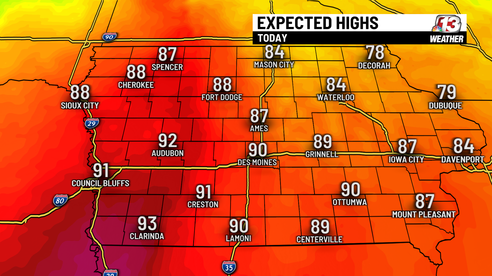
DES MOINES, Iowa — Our below average spring temperatures leaked into the first week of May, but that trend comes to a dramatic end today as temperatures rise into the upper 80s and low 90s.
So far in 2022, there has been one day with highs in the 80s, but that was almost a month ago when highs reached 82° on April 12th. The average high in Des Moines for the first week of May was just shy of 60°. Today, highs will be nearly 30° above that number.
With that, if you have outdoor activities planned for the afternoon and evening, be sure to drink extra water and take frequent breaks to avoid heat-induced illnesses like heat exhaustion and heat stroke. Iowa has not experienced anything close to this level of heat yet this year, so it will take some time for our bodies to adjust to such a stark difference.

Severe weather chances
Severe weather chances will increase tonight as a cold front is expected to move through the state between the late afternoon and the late evening. The Storm Prediction Center shows parts of northeast and central Iowa in a level 1-2 (marginal-slight) risk for severe weather today.

The best chance for severe weather remains across SW Wisconsin and SE Minnesota, but Iowa may still see a few strong to severe storms with this event. Storms look to form mainly east of I-35 and north of I-80 between 6 and 9 PM. Storms that form will have the potential to form tornadoes, large hail, and damaging wind gusts.
As the front slowly moves south and east tonight scattered showers are still likely, however, the severe threat will subside by midnight.
Tuesday
Cloud cover will hold steady throughout the overnight keeping temperatures near 70° for Tuesday morning. Overall winds will be weaker out of the south with highs still reaching the upper 80s to low 90s. There will be a chance for isolated storms after 3 PM Tuesday.

For more on the latest forecast, visit www.WHO13.com/weather.
Continue Reading at WHO13.com here