
Feature your business, services, products, events & news. Submit Website.
Breaking Top Featured Content:
See how much rain your town got with this morning’s storms
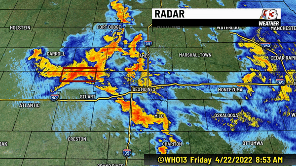
A complex of thunderstorms developed early this morning across Central Iowa with the passage of a warm front. This led to what is called backbuilding of storms for a period of time especially between 8:30 and 10 AM for a few counties. Backbuilding leads to continued heavy rain over the same locations for a period of time. The primary counties impacted included Guthrie, Greene, Carroll, Boone, Dallas, Polk, Story and Jasper.
Sudden rises in water in ditches and roadways where drainage is poor, lead to a brief period of flooding in these spots and a few flash flood warnings.
Here are some of the rainfall totals from the storms:
Maxwell: 3.8″
Melbourne 3.69″
Huxley 3.50″
Saylorville Lake 3.41″
Montezuma: 3.03″
Murray 3.12″
Madrid 2.98″
Sully: 2.79″
Grinnell: 2.72″
Marshalltown 2.67″
Collins: 2.56″
Ames 2.49″
State Center: 2.47″
Perry 2.43″
Pella: 1.98″
Jamaica 1.87″
Des Moines 1.29″
Boone 1.19″
Iowa Falls 1.07″
Ankeny 1.00″
Webster City 0.81″
Hampton 0.57″
Audubon 0.54″
Clarion 0.45″
Chariton 0.42″
Newton 0.28″
Carroll 0.27″
Algona 0.19″
Fort Dodge 0.14″
-

Barb Olsen – Flooding at Briarwood Golf Course -

Mary Jane Nelson – Ankeny


Some strong gusty winds blew in with the storms. This lead to some tree damage in Des Moines with this tree, captured by Justin Surrency.

For the latest forecast, check out who13.com/weather.
Continue Reading at WHO13.com here